
| Field of work |
|
| Projects |
|
| Publications |
Peer-reviewed Journals:
|
| Awards |
|
| Education |
|
Curriculum Vitae
Scientific career
| 10/2004 - 03/2010 | Academic studies of Geodesy & Geoinformatics at KIT |
| 10/2006 | Intermediate diploma |
| 01/2009 |
Seminar paper: Investigation of NURBS functions for the modelling of surfaces with the FLIC software package. |
| 03/2010 |
Graduate Engineer of Geodesy & Geoinformatics |
| 04/2010 - today | Research assistant at KIT, projects: |
| 04/2010 - 01/2013 |
Project HE 1433/17-1 funded by German Research Foundation (DFG): Vertical crustal movements in the Upper Rhine Graben area derived from precise levelling and SAR interferometry |
| 01/2012 - 09/2012 | Analysis of recent surface movements in Northern Switzerland and South-Western Germany for NAGRA (National Cooperative for the Disposal of Radioactive Waste, Switzerland) |
| 01/2013 - 01/2015 | Project HE 1433/17-2 funded by German Research Foundation (DFG): Vertical crustal movements in the Upper Rhine Graben area derived from precise levelling, SAR interferometry and GNSS |
| 01/2015 - 05/2015 | Assessment of surface displacements over gas production fields in Northern Germany, part of DGMK project 776 "Reservoir Management and Seismicity". |
Stay abroad
| 08/2008 - 09/2008 | Participation at the excavation campaign of the German Archeological Institute (DAI) in Pergamon (Western Turkey) Main tasks: Creation of a 3D model of the "castle hill" using GPS measurements, Installation of benchmarks, Surveying of archeological objects |
| 03/2009 | Responsible for surveying tasks at a rescue excavation at a tumulus in Elaia (ancient harbour of Pergamon) Tasks: 3D model of the mound, photogrammetric survey of the tumulus layers |
| 08/2009 | Renewed participation at the summer excavation campaign of DAI (Tasks: see above) |
| 06/2014 - 08/2014 | Research stay at the Department of Geoscience and Remote Sensing, TU Delft, The Netherlands, Cooperation with the Radar Group of Prof.dr.ir. Ramon Hanssen. Main research topic: Combination of surface displacements measured by SAR-Interferometry, levelling and GNSS |
Research and Projects
DFG Project: Vertical crustal movements in the Upper Rhine Graben area derived from precise levelling, SAR interferometry and GNSS
1. Project phase: 04/2010 - 04/2012
Consistent transnational analysis of levelling data in the URG region measured by German, French and Swiss surveying agencies.
Objective: Derivation of vertical displacement rates at levelling benchmarks from a kinematic adjustement of levelling measurements.
Analysed levelling network:
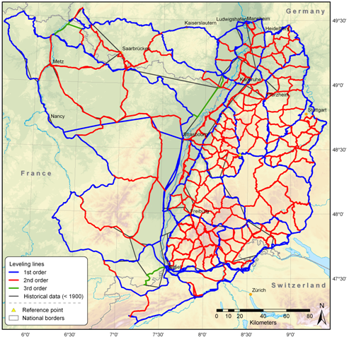
Project partners (data supply):


![]()

2. Project phase: 01/2013 - 01/2015
Analysis of SAR data acquired by ESA's satellites ERS-1/2 and Envisat using Persistent Scatterer SAR Interferometry (PS-InSAR).
Objectives: Derivation of displacement rates from PS-InSAR analyses in the URG region. Comparison, Validation and Combination with results obtained from levelling and GNSS analyses of the GNSS Upper Rhine Graben network GURN.
SAR footprints, GNSS sites and levelling network in the URG region:
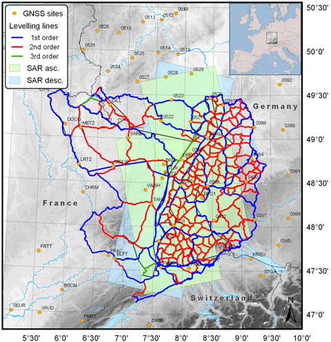
ERS-1/2 and Envisat SAR data provided by:
![]()
Presentation given at the 74th annual meeting of the German Geophysical Society (DGG): Download
Publications
The list of publications can be seen on the German staff page of Thomas Fuhrmann.